‘New generation’ of basin planning

Changes in climate patterns are notably influencing the availability and quality of water resources impacting our economies, societies and the environment. The impacts are evident as described in a UN report (UNISDR), which showed that in the last 20 years, 157,000 people have died as a result of flooding. The report also showed that between 1995 and 2015, floods affected 2.3 billion people, which accounts for 56% of all those affected by weather-related disasters – considerably more than any other type of weather-related disaster. Droughts may not appear as immediate as floods, a recent study on mortality due to extreme weather events indicated droughts to be responsible for more deaths than any other single entity (58%). According to the National Oceanic and Atmospheric Administration (NOAA) drought is the most costly disaster in the USA with an average cost of $9.7 billion per event (NOAA 2018).

With 20% of the world’s population living in river basins that are likely to be affected by increased climate hazard by the 2080s (Kleinen and Petschel-Held, 2007), it is critical that we strengthen our resilience and capacity to mitigate the impacts to sustain our economy, society and the environment we depend on. Water resources are fundamental to the provision of drinking water, for industrial and agricultural use and ensuring the evolution of ecosystems.
As water resources become scarcer, demand from competing sectors will continue to grow. This will drive changes in the way basins are managed in order to continue sustaining the different sectors of the economy, society and environment. The ‘new generation’ of basin planning will need to consider the growing impacts driven by climate variability and change.
Basin planning is the process by which decisions are made over the competing use and different demands for water resources. Basin planning helps to set objectives and the measures for developing, protecting and utilising resources of the basin to ensure availability for different purposes. This requires a more strategic approach that is, of course, well informed and appropriate, and engages across sectors. Such an approach optimises outcomes by reconciling the demands of the different sectors. Such an approach enables a common vision and plan among beneficiaries of basin resources, in which environmental considerations are also embraced.

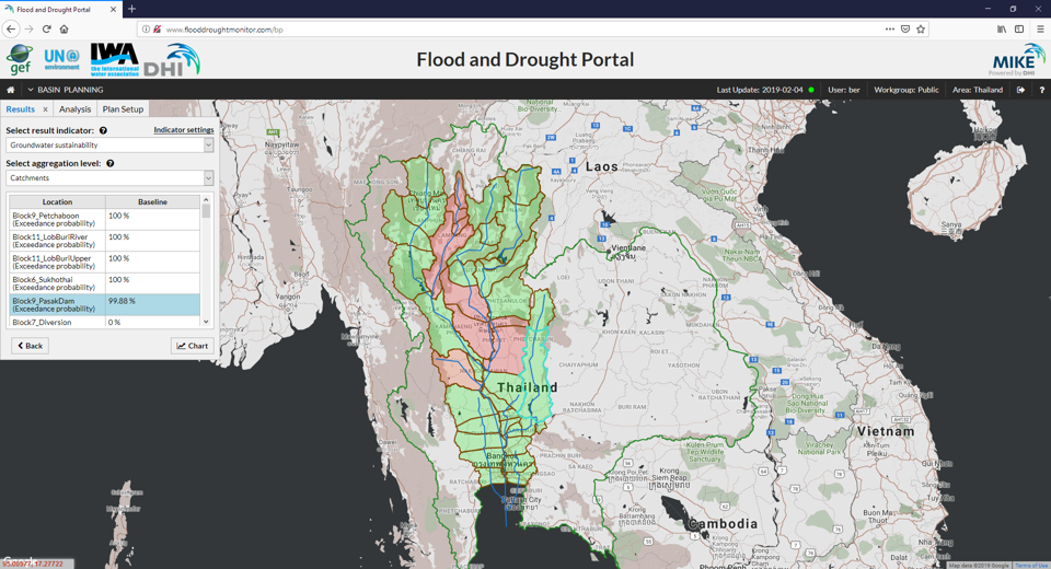
The Flood and Drought Management Tools (FDMT) project (http://fdmt.iwlearn.org), has developed the Flood and Drought Portal (http://www.flooddroughtmonitor.com) which has technical applications to support basin stakeholders include better information on floods and droughts into planning. Water professionals need tools that allow them to integrate climate information and risks into planning. DHI, a member of the International Water Association (IWA) has developed the portal as part of the project which is in partnership with IWA. And in turn the portal and its tools are being disseminated to IWA members, including basin stakeholders.
The Portal gives access to a Basin Planning application helping decision makers or authorities responsible for water management at basin, national, regional or local scale evaluate the impact of a combination of interventions (or investment such as an irrigation scheme, water supply system, hydro power plant, etc.) and external factors (such as climate change or population growth), understood here as the plan, within the basin.
Existing plans can be compared and new plans developed and evaluated. Existing plans are based on a baseline model depicting the current condition of the basin. New plans which incur alterations to the baseline model (i.e. the investments and external factors) are then evaluated using a Multi-Criteria Analysis (MCA) approach. The approach defines the strategy, which includes the concerns or priorities of different stakeholders and selects indicators on which the plans will be evaluated. The weights for each indicator are defined and an overall score is derived for each plan evaluating the impact of the new plan.
The Basin Planning application therefore allows stakeholders to use an advanced hydrological model as an impact tool for evaluation of impacts from investments or external factors. The existing plan can be modified by altering the existing parameters, for example water requirement for a specific water supply or irrigation scheme, and evaluating the impact of the change. All results are evaluated in the form of indicators, where the specific indicators are selected by the stakeholder.
A Crop application has also been developed, which can be used to inform alternations to the existing condition by indicating the increased water requirement for an irrigation scheme to grow a certain crop within the basin. The Crop application is based on the FAO Aquacrop model supporting the assessment of impacts such as climate change on the agricultural sector. The application assists decision makers with planning for crop selection and providing an estimate of the crop water requirement of crops for a specific area of the basin. The application enables stakeholders to use historical, and short- and long-term forecasted rainfall data (provided by the Data and Information application available in the Portal) for computation of crop yields.
For a basin where agriculture precedes other sectors in terms of water use, understanding the annual water requirement for irrigated agriculture to ensure adequate yields can better inform planning and management of water resources in the basin. Entering appropriate information in terms of the investments in new basin plans can ensure that decision makers base their decisions on better informed planning options. Information is the basis for any planning. Information based on sounds information can help ensure that the ‘new generation’ of basin planning scenarios are robust, resilient and pragmatic.
-960px.jpg)
About the Flood and Drought Management Tools project
The Flood and Drought Management Tools (FDMT) project was funded by the Global Environment Facility (GEF) International Waters (IW) and implemented by UN Environment (UNEP), with DHI and the International Water Association (IWA) as the executing agencies. The project developed an online methodology with technical applications to support planning from the transboundary basin to water utility level by including better information on floods and droughts. The project was implemented from 2014 – 2018, with 3 pilot basins (Volta, Lake Victoria and Chao Phraya) participating in development and testing of the methodology and technical applications.
For more information on the Flood and Drought Management Tools project, visit: http://fdmt.iwlearn.org/.
About Oluf Jessen and Bertrand Richaud
 Oluf Jessen is the Head of Projects for Water Resources at DHI-Denmark. He is responsible for all water resources projects from tendering, contract negotiation to project implementation. The project portfolio includes large donor financed projects (World Bank, UN Environment and ADB), government projects and privately funded projects.
Oluf has over 18 years of national and international experience from Australia, Bangladesh, Burkina Faso, Denmark, Germany, Ghana, India, Iran, Italy, Kenya, Madagascar, Malaysia, Malawi, New Zealand, Sri Lanka, Sweden, Thailand, Tanzania, Vietnam, Uganda, and USA.
 Bertrand Richaud is a Water Resources Specialist at DHI with an extensive international experience in water resources management projects, in which advanced IT systems such as information management systems, early warning systems and decision support systems are designed and implemented for various clients (basin organisations, national water resources commissions, hydroinformatics centres, public and private water operators).
Professional experience includes projects in Algeria, Benin, Burkina Faso, Burundi, China, Denmark, France, Ghana, Kenya, Mali, Malawi, RD of Congo, Thailand, Uganda, Rwanda and Zimbabwe.
