IW:LEARN just posted Achieving resilience and environmental security
The backbone of the MAP tri-national region (Madre de Dios, Peru,Acre, Brazil and Pando, Bolivia), the Acre River transboundary basin covers almost 36,000 km2and is home to more than 900,000 inhabitants in Southwest Amazon basin. Its tropical rainforestecosystem is used for diverse economic activities, such as timber extraction, Brazil nuts, precious metals, oil, rice and corn crops, cattle ranching and fishing.
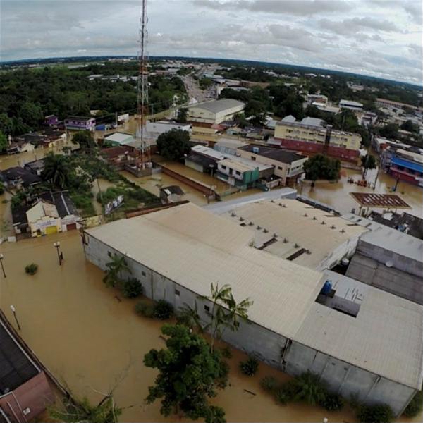
Over the past decades, the basin has been suffering extreme hydro-climatic events, mainly huge floods and prolonged droughts, affecting the local communities, economies, and ecosystems. The GEF funded Amazon Project: Integrated Water Resources Management and Climate Change, implementedby the United Nations Environment Programme (UN Environment), supported the establishment of a tri-national Early Warning System (EWS) looking at determining the vulnerability of ecosystems and communities and, providing those communities with the adaptive capacity to respond to extreme events. Training was provided and, information and data sharing as well as technology transfer was promoted. It fostered cooperation across the borders. More than 40 governmental representatives and 20 civil society institutions from the three countries participated in the initiative.
According to Water Governance expert Elsa Mendoza, who coordinated the pilot project, managing risks and protecting local populations and rainforests is crucial to adaptation. “Reducing the risk of disasters by means of early warning systems and involving communities in monitoring extreme hydro-climatic events are ways of strengthening affected populations,” said Mendoza.
The Early Warning System implemented by the GEF Project helped improve the local governance capacity of Madre de Dios, Acre, and Pando, by anticipating actions for prevention and mitigation of natural and man-made disasters in the region, and monitoring and analyzing environmental risk alerts.
The three countries agreed to use the TerraMA2 development platform as a monitoring, analysis and alert system. It was developed and provided free of charge by the Instituto Nacional de Pesquisas Espaciais (INPE / National Institute of Space Research) of Brazil. They had successfully been using it for years in the State of Acre (Brazil). The use of the same software platform along with the harmonized databases allowed for coordinated actions, alerts and responses between the emergency response units across the borders. The platform generates maps with real-time alert indexes for floods, forest fires and other natural disasters, advancing information exchange and early warning and thus enhancing water and environmental security in this transboundary water basin.
The project had an immediate impact as the EWS was successfully used for the February 2015 historical flood that raised the level of the Acre River to more than 18 meters. It benefited more than 80,000 people in the region.
The System has since been used at the national level across Peru by the National Water Authority.
The success of this transboundary effort highlights the reason why the GEF International Waters Focal area maintains its incremental involvement by funding the next phase of this project, where efforts will be made to help communities across the Amazon basin to become more resilient. The continued role of the GEF in the region under this critical topic of environmental security will provide the government and the people of this region the right tools to adapt to climate change and mitigate its impacts. For more information, please visit http://otca.info/gef/apresentacaoor contact the project at maria.apostolova@otca.org.br.